About Cross River State
Introduction:
Cross River State, tagged the People's Paradise', is situated in Nigeria's Delta region, in the tropical rainforest belt. It lies between latitudes 5°32' and 4°27' North and longitudes 7°50' and 9°28' East, bounded in the North by Benue State, in the South-west by Akwa Ibom State, in the West by Ebonyi and Abia States. The State shares an internal frontier to the East with the United Republic of Cameroon, and its Atlantic coastline is to the south, where the Calabar River meets the sea.
With an area of 23,074 square kilometres and population of 1.8 million, the state is divided into 18 local government areas. Its capital is Calabar and other major towns in the state include Akamkpa, Ikom, Obubra, Odukpani, Ogoja, Okundi, Ugep, Obudu, Obanliku and Akpabuyo.
Cross River State before its creation after Nigeria Independence in 1960 was part of the Protectorate of Southern Nigeria, which was formally merged with the South Eastern Province of Cameroon. It was given a face lift in 1968 when the military administration of General Yakubu Gowon announced the creation of twelve (12) states with the then South Eastern State inclusive with Calabar as its administrative capital.
When the twelve-state structure of Nigeria was later modified to form nineteen states, South Eastern State received a new name and became Cross River State. It emerged in its current form in 1987 when the defunct Armed Forces Ruling Council restructured the nation from a nineteen-state structure to twenty-one. This exercise resulted in the excision of the present Akwa Ibom State from Cross River State.
The climate within Cross River State is tropical-humid with wet and dry seasons, with average temperatures ranging between 15°C - 30°C, and the annual rainfall between 1300 3000mm. The high plateau of Obudu experience climatic conditions which are markedly different from the generalised dry and wet period in the rest of Cross River State. Temperatures are 4°C - 10°C lower due to high altitude than in the surrounding areas. Similarly, the annual rainfall figures are higher than in areas around them, particularly on the windward side. Cross River State can, thus, be broadly divided into the following sub-climatic regions:
- the moderated sub-temperate within the high plateaus of Obudu; and
- the hot, wet tropical extending from the southern lowlands to the central and northern hinterland parts.
For the purposes of administration and governance the Cross River State now comprises eighteen local government areas as shown below in Table:
Within the Cross River State are three major ethnic groups with their dominant languages, the Efik, Bekwarra and Ejagham. These co-exist along with other minor tribes composed of several sub-dialectical groups within the same linguistic background traceable to a common Bantu ancestry. The cultures of the different groups in the State bear striking similarities. The different ethnic groups exhibit this common ancestry through striking similarities in their music, drumming and dancing. Each rhythm and dance expresses the inner feelings of the people which relate to particular events, festivals, or simply their way of life.
Some of the state cultural dances in Cross River State include the "Ikpatimaya" dances from the Obudu in Obanliku Local Government Area, the "Moninkim" dance from the Ikom/Etung Local Government Areas, the Obam dances of Yakure Local Government Area and the Ekpe, Nkwa, Obon, Udoiminyang, Abang dances of the Efiks in Calabar and many others. Traditional festivals relating to farming activities are observed in Yala, Yarkurr, Obubra, Ogoja, Obudu, Obanliku and Boki local Government areas. These festivals are observed annually to celebrate the rich harvest of the season.
Cross River State plays an important role in the national economy, producing significant proportions of the country's basic staples of cassava and yams. Plantation agriculture also contributes importantly through rubber, cocoa, and the indigenous oil palm. Cross River State is the second largest timber producer in the country, and its coastal mangroves support an economically important national fishery. Cocoa is an important tree crop in Cross River State, and although cocoa can be incorporated within viable agro-forestry systems, its increased planting has put additional pressure on natural forests. Over 99% of Cross River indigenes living in fishing communities are engaged in artisan fishing, subsistence farming and local trading. The fishing activities are carried out in the mangrove creek, the estuary and nearby coastal zone (outer estuary). The economic well- being of these communities are determined by the catch per unit effort during each outing.
The Cross River State economy is predominantly agricultural which is sub-divided into two sectors - the public and the private sectors. The private sector is dominated by local subsistence farmers while the public sector is run by the Government and features large plantations and demonstration farms. The main crops are cassava, yams, rice, plantain, banana, cocoyam, maize, cocoa, rubber, groundnut and palm produce.
Support of this natural resource base is thus consistent with planned national priorities; the Federal Government dedicates about one-third of its primary and secondary sector expenditures to such activities. General developments over the past year have not to any large degree altered these circumstances. The following two additional factors relating to Federal macroeconomic initiatives are, however, of potential relevance to conservation efforts.
Food import bans are being effectively enforced for many basic foodstuffs and have indirectly placed upward pressure on farm prices. As there is general agreement that supplies from rural sectors respond to both higher prices and to substitution opportunities, Government is expected to maintain this strategy at least in the near-term. This, through the same price mechanisms discussed above, will increase use of extensive cultivation practices.
Farm price deregulation has increased output prices in rural areas, thus increasing
incentives to augment production efforts at the rural level; at forest margins and
other areas where ingress of populations cannot be controlled, this has contributed to
increased pressures on environmentally fragile areas. Most augmentation in rural production has therefore not always resulted in intensification but, rather, has leaned towards using more extensive techniques of production. Again, at forest margins, this has increased the pressures towards clearing new land for agricultural purposes.
Cross River State is very rich in biodiversity. It harbours several species of primates, migratory and resident birds, and 950 species of butterflies -a quarter of the number to be found in tropical Africa - 100 of which are not found anywhere else and at
least three are new to science. Many of Africa's rarest trees, such as mahogany, ironwood, camwood and mimosup, grow in this forest connected to the larger tropical forest area in neighbouring Cameroon. The region also includes one-third of Africa's primate species -- the most endangered rare and unique gorillas, drill monkeys are found here, hippopotamuses, chimpanzees, elephants, grey parrots and an incredible diversity of migratory and resident birds as well as other endangered animals and plants.
Cross River National Park
Between 70 and 80% of Nigeria's original forests have been lost and presently the area of its territory occupied by forests is reduced to 12%, even though the entire country is located in the humid tropics. All of the country's remaining primary rainforest watersheds, covering about 7,000 km2 are located within Cross River State. A total of 6,202 square kilometres within Cross River State is covered with thick forest and accounts for about 32 percent of the landmass area of the state (Forest Sector Strategy, 1994).
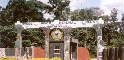
Cross River National Park |
Cross River State contains the largest amount of Tropical High Forest remaining in Nigeria and largest remaining rainforest in West Africa (0.85 million hectares), although its quality and density varies across the State's three agro-ecological zones. Cross River State also contains 1,000 sq. kilometres of mangrove and swamp forest. The main tree species found here include gmelina, albizia, iroko, ebony, mahogany, cedar, ukong, brachystegia and obeche. Cross River State due to her rich biodiversity and ecology remains an ideal biometry resource data base for tropical plant and animal research.
|
The Cross River National Park in Cross River State comprises of two components, the Okwangwo Division (ca 920 sq. km.) to the north of the Cross River, north of Ikom and about 4 hours drive from Calabar and the Southern Oban Hills portion, the Oban Division (ca 2,800 sq, km.) in the vicinity of Oban to the south of the Cross River and takes an hour drive north of Calabar.
The Okwangwo Division in Nigeria and the Takamanda Forest Reserve in Cameroon comprise one continuous moist-forest system, and several major tributaries of the Cross River rise in the forests of the Division before flowing into Cameroon (where the Cross River itself originates partly as drainage from Takamanda), These make the area's regional watershed role particularly important.
This is part of the Cross River National Park rainforest conservation area, located in Boki LGA. The park extends from Kanyan to the foot of the Obudu Plateau. It has a total land area of 920 sq. km. Its unique natural features which include rugged mountain scenery and rolling hills, explain why it has been described by a 1979 UNESCO Report as one of the finest places in the world.
Agbokim Waterfalls
The Cross River State is one of the estuarine states in Nigeria with a low-energy, shallow coastal waters and shorelines. The Cross River estuary is the largest estuary in Nigeria with the highest tidal amplitude (3m). A very short distance away from the Nigeria-Cameroon border is the very attractive and impressive tourist spot called Agbokim Waterfalls. The Waterfalls lies less than 30km east of Ikom town in Cross River State, and is actually situated on the estuary of the Cross River, where it descends in terraces, through the tropical rainforest. The visage and captivating sight of falling sheets of water consisting of seven different streams each cascading down very steep walls at different points pleasantly surrounded by lush green vegetation, and covered by a rainbow aura is indeed spectacular. The surrounding areas within the vicinity of the falls are highly recommended for group/family picnics.
Kwa Falls:
Another spectacular waterfall, the Kwa falls drained through the Oban Hills and Mountain, is located in a narrow, steep gorge on the headwaters of the Kwa River, where it cascades down resistant basement rocks. A deep plunge pool forms at the bottom of the waterfall, which, before deforestation, was hidden under the thick canopy of the tropical rainforest.
Both Agbokim and Kwa Falls could be harnessed to generate hydro-electric power, with Agbokim Waterfall exhibiting better potentials than Kwa Falls.
|